
Frequently Asked Questions
Most likely your architect needs a topographic map in order to design a new residence or to design a remodel of an existing residence. The topographic map will show existing features on the property, as well as showing the contour lines which delineate lines of a constant elevation. If you are remodeling an existing home, it will be critical for the architect to know the setbacks from the existing home to the property lines. If you are expanding the footprint of your new construction right up to the setback lines, we would advise that a boundary survey be completed as well. This involves establishing your boundary lines based on the recorded deed and permanent, property corner monuments on the ground. With the boundary survey completed, your contractor now has the property lines clearly staked in the field prior to beginning construction.
The most common types of surveys are topographic and boundary surveys.
A topographic survey will determine the relative elevations of the property, along with showing planimetric features, such as: structures, fencing, walls, tree trunks and tree canopies, surface evidence of utilities, and curbs or pavement. The topographic map may also graphically depict the property lines if adequate control can be found in the field, however; missing property corners are not set unless a boundary survey is also requested (see below).
The cost of a topographic survey depends on these factors:
1. Size of the parcel
2. Slope of the parcel
3. Amount of vegetation and/or obstructions on the parcel
4. The distance of the site from our office
Please contact us with your assessor’s parcel number and we can determine an estimate of costs based on your specific needs. We can also use resources on the web (Google Maps) to review the terrain and amount of vegetation in the area.
A boundary survey will determine the boundaries of your parcel and set physical monuments in the ground in conformance with state law (Land Surveyor’s Act). This includes:
1. The length of time since the original survey was performed
2. Whether the lot was created by subdivision map or by deed
3. How much existing monumentation is available in the site area.
Large parcels in sectionalized land (square mile sections) can be extremely challenging. The original surveys that were completed in 1860’s set wood posts with mounds of rock every half mile on the perimeter of the one-mile square “sections”. In some cases, “bearing trees” are referenced with a bearing and distance to the corner. Sectionalized land is normally in very rugged terrain, and finding evidence of the original surveys after 160 years is a challenge. These types of surveys can cost thousands of dollars and may take months to complete.
The cost of a topographic survey depends on these factors:
1. Size of the parcel
2. Slope of the parcel
3. Amount of vegetation and/or obstructions on the parcel
4. The distance of the site from our office
Please contact us with your assessor’s parcel number and we can determine an estimate of costs based on your specific needs. We can also use resources on the web (Google Maps) to review the terrain and amount of vegetation in the area.
A boundary survey will determine the boundaries of your parcel and set physical monuments in the ground in conformance with state law (Land Surveyor’s Act). This includes:
- Title research to determine how the parcel is described and how the parcel was created.
- Preliminary calculations in the office to determine “search locations” for property monuments on the subject property or on surrounding parcels.
- A retracement survey to search for evidence of original surveys and subsequent surveys.
- Office calculations to resolve the boundary based on monuments found during the retracement survey.
- A second trip to the site to set final monuments. The monuments may consist of galvanized pipes or rebar along with a brass tag or plastic cap bearing the surveyor’s license number.
- Preparation of a Corner Record map or Record of Survey map for submittal to the County as required under state law (LS Act Section 8762).
1. The length of time since the original survey was performed
2. Whether the lot was created by subdivision map or by deed
3. How much existing monumentation is available in the site area.
Large parcels in sectionalized land (square mile sections) can be extremely challenging. The original surveys that were completed in 1860’s set wood posts with mounds of rock every half mile on the perimeter of the one-mile square “sections”. In some cases, “bearing trees” are referenced with a bearing and distance to the corner. Sectionalized land is normally in very rugged terrain, and finding evidence of the original surveys after 160 years is a challenge. These types of surveys can cost thousands of dollars and may take months to complete.
Not really. GPS is just a tool for measurement. GPS has not changed the way our retracement surveys are performed, rather, it has only changed the way we acquire the field information. The methods of re-establishing boundaries have not changed much in the last 150 years. Even with GPS as a measuring tool, we still have to find evidence of the original surveys based on the same methods that were common in the 1800’s.
In other words, there is no public database available with everyone’s corner positions stored with latitude and longitude coordinate positions.
In other words, there is no public database available with everyone’s corner positions stored with latitude and longitude coordinate positions.
Maybe. If the parcel is in County jurisdiction, there are many factors that come into play to determine whether or not the parcel can be subdivided. A few of them are:
If the parcel is within an incorporated City, then a planner will need to investigate the subdivision requirements within that jurisdiction according to local zoning ordinances.
- Remoteness test (distance to an urban reserve line)
- Fire Hazard/ response time (distance to nearest CDF station)
- Access standards (access to County maintained road)
- Slope test (the steeper the slope, the larger the parcel)
- Water supply
- Specific overlays (scenic, geologic study, etc.)
- Sewer services (community sewer or septic)
- Minimum parcel area
- Soils Classification
If the parcel is within an incorporated City, then a planner will need to investigate the subdivision requirements within that jurisdiction according to local zoning ordinances.
No. The practice of Land Surveying is regulated by the State under the California Land Surveyor’s Act https://www.bpelsg.ca.gov/laws/pls_act.pdf. This law act requires surveyors that set monuments in the ground to file a Corner Record map or Record of Survey map with the County. Any surveyor that sets a monument without filing the appropriate record map with the County is in violation of the law and risks losing their license to practice.
Maybe or maybe not. A Certificate of Compliance is a certification from the local agency that the parcel was created in conformance with local and state subdivision regulations at the time the lot was created. In order to investigate the legal status of a parcel, it is first necessary to obtain a title report and complete chain of title for the parcel. If title research determines that your parcel was created illegally, the agency may issue a “Conditional Certificate of Compliance.” This document may require you to perform a lot-line adjustment with the adjacent property to bring the parcel into conformance, or you may have to merge the parcel with an adjacent parcel (i.e.: voluntary merger) that you also own.
I am often asked- Why is a survey in sectionalized land so expensive? Can’t you just setup on a corner and turn 90-degree angles to set the others?
The short answer is: “no, we can’t”. The long answer is much more difficult to explain.
The United States Public Land Survey System (PLSS) began with the Land Ordinance of 1785. This ordinance provided for the systematic survey and monumentation of the federal lands into townships (36 square miles) and sections (one square mile). The PLSS surveys in California began in 1851, soon after statehood and most of the surveys in San Luis Obispo County were performed in the 1860’s.
The intent of the system was to survey and monument the western lands of the U.S. prior to issuing patents to private citizens. The sections (one mile square) provided a standard size and shape of parcel with reference to the township and initial points (i.e. Mt Diablo base and meridian). This system allowed for descriptions of the land to include simple aliquot part descriptions, which divided the sections into halves or quarters and to allow for a specific description of a certain parcel of land. An example might read as follows:
The NW ¼ of the SE ¼ of Section 20 of Township 32 south, Range 12 East, Mount Diablo Base and Meridian.
The methods and procedures used to survey PLSS parcels are described in the “Manual of Survey Instructions” which is published by the Bureau of Land Management (BLM). The “Manual” describes very specific standards by which townships, sections and portions of sections are surveyed. Every licensed land surveyor is required to follow these methods and procedures. The original surveys of the 1800’s called for monuments to be placed at the section corners and at ¼ section quarters so that a typical one-mile square section of land would include 8 monuments (with monuments set at ½ mile intervals). These original monuments would consist of a 4”x4” wood post and a mound of rocks placed around the post (if rocks were available). Also, in wooded areas, bearing trees would be identified as an accessory witness points to the corners. The size and type of the tree would be noted and the bearing and distance from the corner to the tree would be called for in the original field notes which are available from the BLM.
The original PLSS surveys were performed with a magnetic or solar compass, and Gunter’s chain (66 feet long). Distances in chains allowed for easy calculations for area. A typical 640-acre section measured 80 chains by 80 chains. Obviously, when we find evidence of the original surveys, we discover huge discrepancies between the original measurements and our current measurements. These discrepancies can be up to hundreds of feet within a section in heavily wooded and mountainous terrain.
The interior lines of a section where never surveyed, so under state and federal law, the entire perimeter of the section must be re-established in order to properly subdivide the section into its aliquot parts. This means that if you owned a 10-acre parcel within a section, we are required to establish the boundaries of the entire 640-acre section in order to properly establish the boundaries of the 10-acre parcel within the section. These procedures ensure that no gaps or overlaps are created within the interior portions of the section, which would obviously result if each surveyor used a different beginning line to start a survey.
Since usually less than a third of the original PLSS monuments exist today (150 years later), re-surveys of these ancient surveys are extremely challenging. Most of these surveys are in extremely rugged terrain, with 100% slopes, thick brush and very limited access. If we are required to hike our equipment into search for a corner, we often only have time to look for a single corner in an 8-hour work day.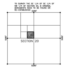 As an example, let’s look at the following survey of a 10- acre parcel in section 20. Eight original corners need to be found or re-established. This could take a two-person crew anywhere from a few days to up to 8 days.
Once the retracement survey is completed, the field data is brought back to the office for analysis and map preparation. Once the boundary is resolved, it is submitted to the County Surveyor for review and approval. Monuments are then set on the corners of the 10-acre parcel.
Let’s look at another example, where we were not so lucky to find all 8 section corners. This is a more realistic scenario, especially for a section that has never been retraced since the 1800’s. In this example, we have found the NE, NW, & SE section corners, and the W1/4 corner. The E1/4, S ¼ and SW section corners were not found. We are then required to search adjacent sections (19 and 29) to find adequate control to re-establish the SW corner. Once the ¼ corners in sections 19 and 29 are found, the SW section corner can be re-established by proportion.
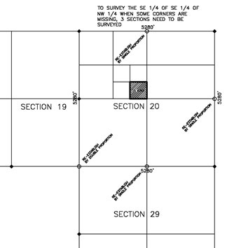 As you can see from the examples above, what would seem to be a simple survey of 10 acres, soon can expand to a retracement of over a square mile (640 acres) of land.
For these reasons, retracements of land within the PLSS can take days of research, weeks of retracement surveying in steep and brushy terrain, and days of calculations and map preparation. These types of surveys can often cost $10,000 or more and take months to complete.
The short answer is: “no, we can’t”. The long answer is much more difficult to explain.
The United States Public Land Survey System (PLSS) began with the Land Ordinance of 1785. This ordinance provided for the systematic survey and monumentation of the federal lands into townships (36 square miles) and sections (one square mile). The PLSS surveys in California began in 1851, soon after statehood and most of the surveys in San Luis Obispo County were performed in the 1860’s.
The intent of the system was to survey and monument the western lands of the U.S. prior to issuing patents to private citizens. The sections (one mile square) provided a standard size and shape of parcel with reference to the township and initial points (i.e. Mt Diablo base and meridian). This system allowed for descriptions of the land to include simple aliquot part descriptions, which divided the sections into halves or quarters and to allow for a specific description of a certain parcel of land. An example might read as follows:
The NW ¼ of the SE ¼ of Section 20 of Township 32 south, Range 12 East, Mount Diablo Base and Meridian.
The methods and procedures used to survey PLSS parcels are described in the “Manual of Survey Instructions” which is published by the Bureau of Land Management (BLM). The “Manual” describes very specific standards by which townships, sections and portions of sections are surveyed. Every licensed land surveyor is required to follow these methods and procedures. The original surveys of the 1800’s called for monuments to be placed at the section corners and at ¼ section quarters so that a typical one-mile square section of land would include 8 monuments (with monuments set at ½ mile intervals). These original monuments would consist of a 4”x4” wood post and a mound of rocks placed around the post (if rocks were available). Also, in wooded areas, bearing trees would be identified as an accessory witness points to the corners. The size and type of the tree would be noted and the bearing and distance from the corner to the tree would be called for in the original field notes which are available from the BLM.
The original PLSS surveys were performed with a magnetic or solar compass, and Gunter’s chain (66 feet long). Distances in chains allowed for easy calculations for area. A typical 640-acre section measured 80 chains by 80 chains. Obviously, when we find evidence of the original surveys, we discover huge discrepancies between the original measurements and our current measurements. These discrepancies can be up to hundreds of feet within a section in heavily wooded and mountainous terrain.
The interior lines of a section where never surveyed, so under state and federal law, the entire perimeter of the section must be re-established in order to properly subdivide the section into its aliquot parts. This means that if you owned a 10-acre parcel within a section, we are required to establish the boundaries of the entire 640-acre section in order to properly establish the boundaries of the 10-acre parcel within the section. These procedures ensure that no gaps or overlaps are created within the interior portions of the section, which would obviously result if each surveyor used a different beginning line to start a survey.
Since usually less than a third of the original PLSS monuments exist today (150 years later), re-surveys of these ancient surveys are extremely challenging. Most of these surveys are in extremely rugged terrain, with 100% slopes, thick brush and very limited access. If we are required to hike our equipment into search for a corner, we often only have time to look for a single corner in an 8-hour work day.
As an example, let’s look at the following survey of a 10- acre parcel in section 20. Eight original corners need to be found or re-established. This could take a two-person crew anywhere from a few days to up to 8 days.
Once the retracement survey is completed, the field data is brought back to the office for analysis and map preparation. Once the boundary is resolved, it is submitted to the County Surveyor for review and approval. Monuments are then set on the corners of the 10-acre parcel.
Let’s look at another example, where we were not so lucky to find all 8 section corners. This is a more realistic scenario, especially for a section that has never been retraced since the 1800’s. In this example, we have found the NE, NW, & SE section corners, and the W1/4 corner. The E1/4, S ¼ and SW section corners were not found. We are then required to search adjacent sections (19 and 29) to find adequate control to re-establish the SW corner. Once the ¼ corners in sections 19 and 29 are found, the SW section corner can be re-established by proportion.
As you can see from the examples above, what would seem to be a simple survey of 10 acres, soon can expand to a retracement of over a square mile (640 acres) of land.
For these reasons, retracements of land within the PLSS can take days of research, weeks of retracement surveying in steep and brushy terrain, and days of calculations and map preparation. These types of surveys can often cost $10,000 or more and take months to complete.